Sunday 8 December 2024
The Woodlands and Park of Launde Abbey
Guest blogger, Andy Lear, explores both the historic woodland boundaries and the possible location of a medieval deer park at Launde Abbey.
Launde Abbey in east Leicestershire (Fig. 1) is a modern Christian Retreat House on the site of the former Launde Priory. The latter was established before 1125 and dissolved in 1539 (VCH Leics vol 2, 1954). Only parts of the original chapel survive.
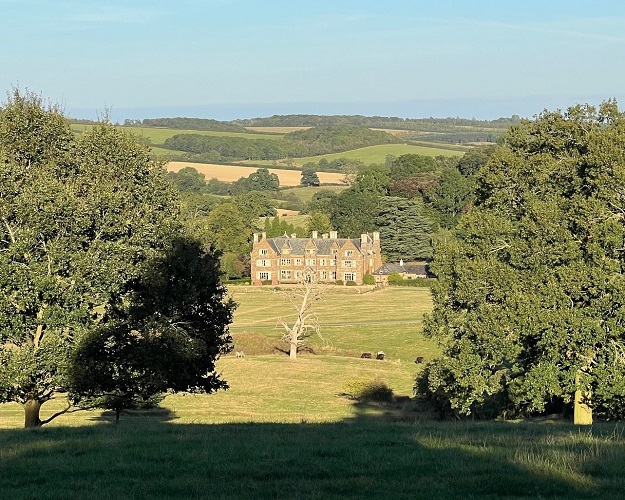
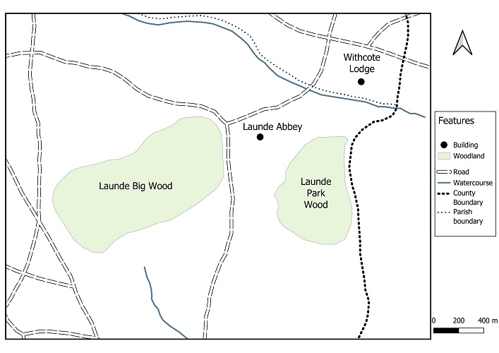
The Abbey is set in parkland and lies between two ancient woodlands – Launde Big Wood to the west and Launde Park Wood to the east (Fig. 2). The area was once within the short-lived Royal Forest of Leicestershire, an extension of the Forest of Rutland created by Henry I around 1122 and disafforested by Henry III in 1235 (Crook, 2013). In 1248 the prior and canons of the Launde Priory were given a licence to ‘enclose their wood situate on the borders of Rutland with a ditch and a fence and convert it into a park’ Cal. Pat. Rolls, 1247-58,326 (Squires 2004). This most likely refers to Launde Park Wood, but potentially might include Launde Big Wood (formerly West Wood) which was also in the possession of the Abbey. At dissolution, the Priory and its lands fell into the hands of Thomas Cromwell, but he was executed before he could live there. It was inherited by his son Gregory and sold by the Cromwells at the start of the 17th century and has since passed through several ownerships up to the present day.
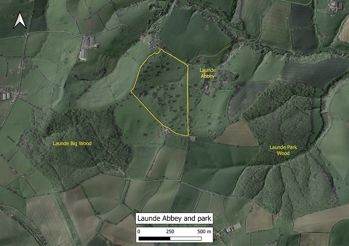
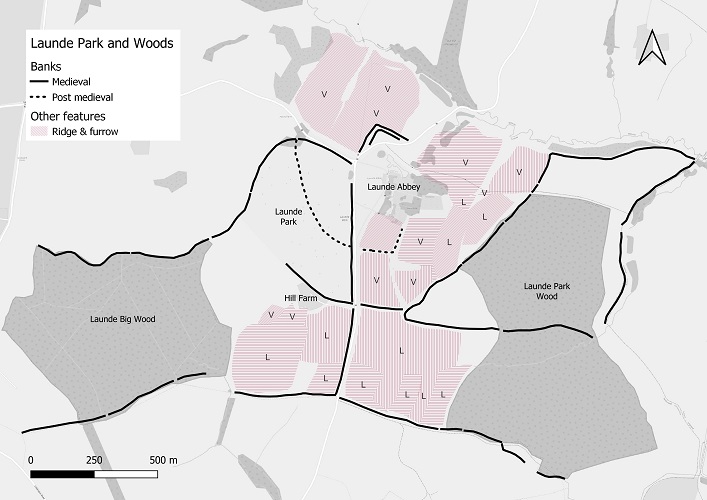
The Abbey lies within a steep bowl with parkland on its west flank (Figs. 1 & 2). There are a number of earthworks associated with the Abbey, the park and the adjacent woodland (Hartley, 2018). These include banks thought to be of medieval origin (Leicestershire & Rutland HER refs MLE1838, 1839, 1840, 1843, 1844) and a less substantial bank cutting across the park thought to be post medieval (MLE1845). (Although Hartley (2018) suggests the latter is possibly a medieval park bank). These banks are visible on the 1m DTM LiDAR image of the area, along with medieval ridge and furrow. Other areas of ridge and furrow have been ploughed out but were mapped by Hartley from 1940s RAF aerial photographs. These features are shown in Fig 3. Many of the banks can easily be viewed on the ground except for the southern-most section of the bank running north to south through the middle of Fig. 3, which was identified by aerial survey.
This article sets out to identify historic woodland boundaries around Launde Abbey and the possible function of the banks within the current park. It shows that the present park originated in the early nineteenth century and is distinct from the medieval deer park once associated with Launde Priory. The potential boundary of the deer park is proposed.
The earliest map showing the area is a 1586 estate map of the parish of Whatborough produced for All Souls College, Oxford, who held lands near Launde. Fig. 4 is an extract of this map showing Launde Abbey in the bottom right-hand corner and Launde Big Wood, labelled ‘Parte of Launde groundes’, running along the bottom. The map has been aligned with contemporary maps and the possible medieval and later banks in the north part of the current park overlaid. One of the extant banks clearly marks the northern edge of Launde Big Wood which can be seen extending right up to the Abbey. The other bank marked with a solid line running north-south, at least in part, seems to delineate the eastern edge of the wood before continuing into the drawn wooded area. From this map it is clear that Launde Big Wood once occupied much of the current Launde park. The possible post-medieval bank, shown with a dotted line, runs through the wood to the west of the Abbey but the east portion, once it crosses the solid line of the medieval bank, appears to match the wood boundary. A closer examination of Fig. 3 and maps in Hartley (2018) shows that this part of the bank marks the boundary between different furlongs of a former open field system delineated by the ridge and furrow pattern, and therefore could represent a former baulk between cultivated strips.
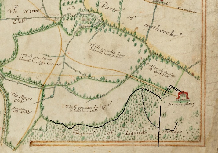
Launde Priory enclosed their land in the adjoining parish of Whatborough in 1495 (Hutchings 1989) and Launde itself was also enclosed early (before 1550, Hartley, 2018), possibly about the same time, since former arable land to the south of the Abbey is shown as woodland on the 1586 map. This section of bank is therefore medieval.
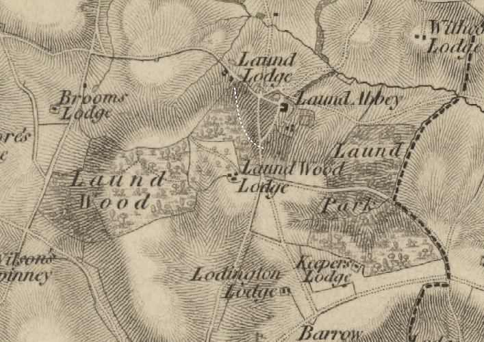
The 1777 county map by John Prior, (Fig. 5) confirms the eastward extent of Launde Big Wood, with the boundary running alongside the road passing in front of the Abbey. This supports the conclusion that the bank still visible beside the road running through the park today is in fact a former wood bank (Fig. 6).
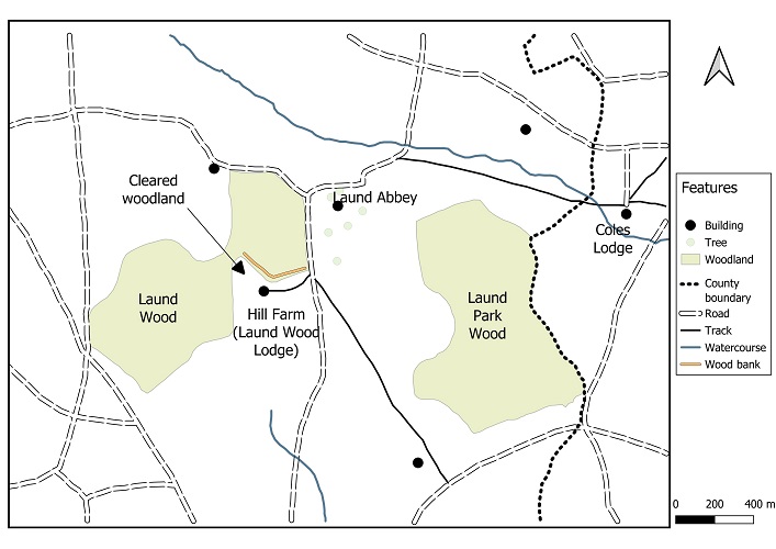
A later map by William King from 1806 (Fig. 7) similarly shows the wood extending up to the road in front of the Abbey and occupying all of the area of the modern park. The most noticeable change is the open triangular area almost cutting the wood in two (labelled cleared woodland). A visible bank (indicated by the solid white line) corresponds to the east side of this triangle, continuing on the north side of Hill Farm (formerly Laund Wood Lodge) and up to the road. Woodland clearance might have been more extensive. Prior’s 1777 map (Fig. 5) possibly shows that the wood extended south of the farm. Similarly, a 1758 map entitled A survey of Launde Closes and a close in Leighfield Forest, by Edmund Dipper (ROLLR: DE3214/4587) labels the area as woodland but the extent is not mapped. The Leicestershire and Rutland HER (MLE 1840) records a former wood bank to the west of the road (Fig. 3). If this is correct it can’t always have been woodland since 1940s aerial photography revealed extensive ridge and furrow across the area, indicating it was once cultivated land. Any woodland here would have had to develop after enclosure of the open fields (some time before 1550) and to have been cleared between 1758 and 1806.
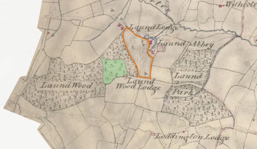
If we look at a slightly later map – the 1814 Ordnance Surveyors drawing (Fig. 8) - the triangular open area noted in Fig. 7 is drawn with scattered trees (shaded green in Fig. 8) and is more open than the adjoining woodland. Rather than parkland, which on these maps is marked by stippling (for instance as drawn to the west of the Abbey and outlined in orange), this might represent open wood pasture or woodland in the process of actively being cleared. The difference between the two maps (open ground in Fig. 7, and individual trees in Fig. 8) could just be down to how the different surveyors viewed a landscape with scattered trees. Also note that the wood no longer reaches the road in front of the Abbey and a section has been sliced off and is drawn as parkland. This can also be seen on the 1824 OS 1” 1st series map (Fig. 9). The line dividing the wood from the park corresponds to the post medieval bank drawn in Fig. 3. This bank is fairly substantial and can still be seen (Fig. 10). This clearly represents a park boundary as suggested by Hartley (2018), but from the evidence of these maps it is probably of early nineteenth century origin rather than being medieval. The fact that there is a physical boundary dividing the park from the wood suggests that the area lost from the wood in 1814 was a single process with a defined outcome, and that the mapping was not capturing a stage in an active and on-going woodland clearance.

By the 1880s the park had been enlarged (Fig. 11), and most of the area between what is now the east side of Launde Big Wood, and the Abbey is shown as scattered trees and was probably wood pasture or parkland.
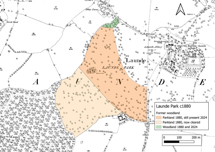
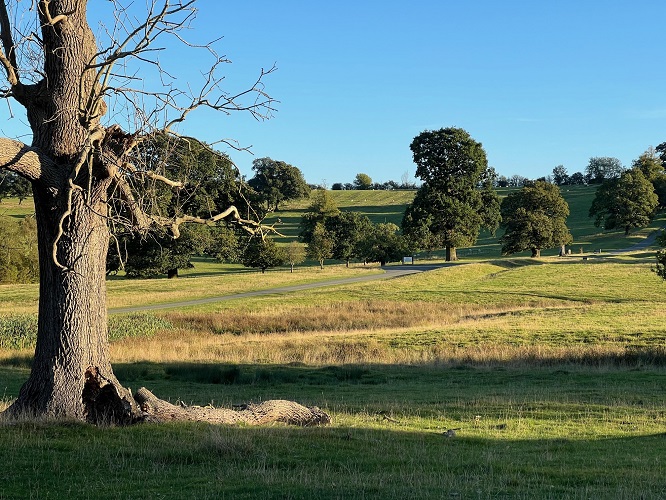
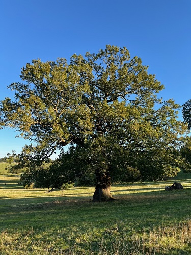
If you compare Fig. 11 with current satellite imagery (Fig. 2) you will see that most of the trees to the west of Hill Farm have now been cleared, but a small fragment of the original wood remains at the northern tip of the park next to Abbey Farm. This area still retains some large oaks and ancient woodland indicators plants typical of this type of woodland. Within the body of the current park many of the trees are of more recent origin, but some large old oaks (Fig. 12) can be found towards the north and south margins. These possibly originated in the early 19th century and might be relics of the former wood. Some of these trees correspond with trees mapped on the 1:2500 Epoch 1 map (Fig. 11).
In summary, it is apparent from this series of maps, that the current parkland at Launde Abbey originated from former woodland during the mid-19th century.
Turning to the other wood belonging to Launde Priory, Launde Park Wood, we can see from Fig 3, that it is also associated with a number of significant banks. Since the wood has been documented back to 1248 (Squires, 1995) and is thought to be the wood which was emparked in the thirteenth century to create a deer park (Squires 2004), it can be concluded that the banks are of medieval origin. The wood lies outside the area mapped in 1586 but has remained very much the same shape since at least the late eighteenth century (Figs. 5,7,8,9). The only change between 1824 and the present day is that a strip was cleared along the east edge up to the Leicestershire- Rutland boundary, probably sometime in the 1860s (Leicestershire & Rutland Wildlife Trust, unpublished) as shown on the 1884 OS map (Fig. 13).
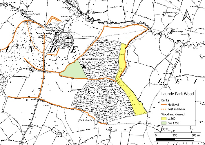
To date I have not located any maps showing Launde Park Wood directly before John Prior’s 1777 map (Fig. 5). However, the Record Office does have several maps which show the land in Leighfield bordering the wood. These indicate that the edge of the wood extended up to the parish boundary (ROLLR DE3214/4605 Plan of Ridlington and Leighfield 1625, DG7 3443 Estate map of land in the Forest of Leighfield 1780). The latter names Lawn Wood with a northern edge exactly aligning with the current wood. It also labels the open ground north of the wood as Lawn Ground. It would seem that this area has been open since the seventeenth century.
On the west side of the wood the course of the banks suggests that an area of woodland tinted green in Fig. 13 has been cleared. Note the new straight boundary lacks a bank. No ridge and furrow was recorded for this triangular piece of land on 1940s aerial photographs (Harley, 2018), supporting the supposition that it was once woodland. It was probably cleared some time before the second half of the eighteenth century.
The southern boundary of Launde Park Wood is marked by a wood bank which then extends westwards forming the boundary between Launde and Loddington parishes, until meeting the wood bank forming the southern boundary of Launde Big Wood. Since much of the intervening land between the two woods was once ridge and furrow (Fig. 3) the parts of the bank between the two woods might just represent a parish boundary, rather than a former wood bank. Whichever is the case, the bank along the parish boundary probably originated at the same time as those on the south side of the woods and is therefore likely to be of medieval origin.
Having identified former areas of woodland and their relationship to extant wood banks, a question arises about the location of the medieval deer park. It clearly wasn’t the current park. Nor was it to the north of the Abbey as can be seen on the 1586 map (Fig. 4) which names the location as Burthett/Burfytt/Burfielde – the site of a former settlement. This area is also full of ridge and furrow and therefore part of the medieval open fields around the time the park was created in 1248. The obvious location for the deer park is Launde Park Wood. Hartley (2018) suggests that the bank dividing the Park Wood into two halves was part of a medieval park boundary but doesn’t speculate further on the remaining boundaries. Although medieval parks could vary greatly in size many were around 40-80 hectares. They often had a rounded outline to minimise costs for creating the encompassing boundary bank topped with a pale fence which helped to contain the deer. There is only one likely looking area in the vicinity of the Abbey which would seem to fit and is totally enclosed by a bank. This is the approximately 40 ha enclosure comprising: the north half of the Park Wood, the field between the wood and the River Chater to the north, and the strip between the wood and the Launde/Leighfield parish boundaries to the east. It also includes the area extending from the southwest corner of the wood, (Fig. 14). I therefore propose that this represents the area of the medieval deer park. The open ground to the north could well be the site of a ‘lawn,’ an open grassy area, a feature within many deer parks, consistent with it being named Lawn Ground on the 1780 map. If this is indeed the deer park then Launde Park Wood was once two woods, one within the park and one outside. The Forestry Commission replanted much of the southern two thirds of the wood with a mix of conifer and broadleaved trees in the 1960s and 70s so it is difficult to determine whether there are any vegetation differences between the two parts, which might have marked different management regimes. In addition, the replanting involved removing old coppice stools with machinery, thus potentially damaging any remaining archaeological features. Keeping all this in mind, it is still noticeable that some parts of the wood within the putative deer park have a grassy ground flora which might indicate a history of grazing/ wood pasture consistent with being such a park. Please note though that this is only speculation and requires further research.
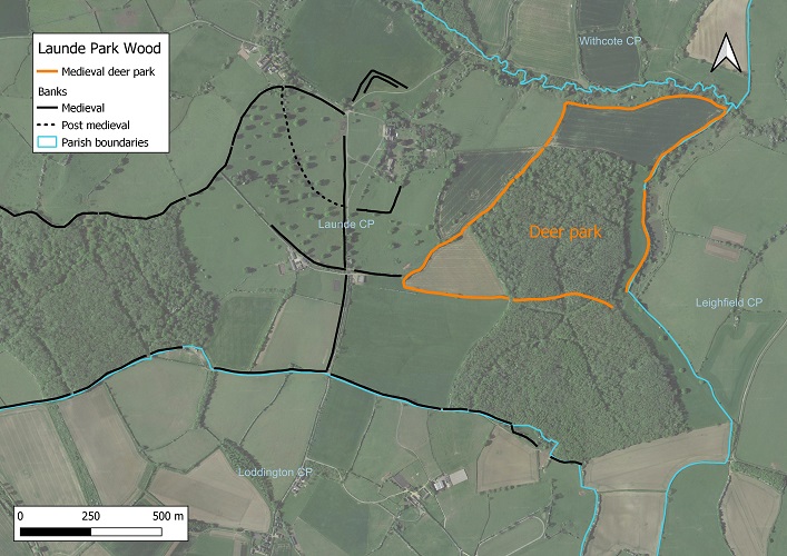
To sum up, the area around Launde Abbey, its park and adjoining woods, contain many landscape features which reflect its history. Most obvious to the casual visitor are the large banks which exist within the park itself. I hope to have demonstrated that these are former wood banks, many probably of medieval origin, and mark the former extent of Launde Big and Park Woods. The current park to the west of Launde Abbey was woodland until at least 1806. It is mainly a mid-nineteenth century creation, but with a few relic trees and a small area of older woodland remaining. The medieval deer park was elsewhere within the former Priory’s land holding, with the most likely location being to the east of the Abbey comprising the northern half of Launde Park Wood and two adjacent fields.
Andy Lear, Former Ancient Woodland Inventory Officer at The Wildlife Trust for Bedfordshire, Cambridgeshire & Northamptonshire. 2024.
Citations
Crook, D., 2013. ‘The Royal Forest of Leicestershire, c1122-1235’. Transactions of the Leicestershire Archaeological and Historical Society, 87, 137-160.
Hartley, R. F., 2018. The Medieval Earthworks of South & South-east Leicestershire. Leicestershire Fieldworkers Monograph 4.
'Houses of Augustinian canons: The priory of Launde', in A History of the County of Leicestershire: Volume 2, ed. W G Hoskins, R A McKinley (London, 1954), British History Online. [accessed 22 October 2024]
Hutchings, N., 1989. ‘The Plan of Whatborough: a study of the sixteenth-century map of enclosure.’ Landscape History, 11, 83-92.
Squires, A. E., 1995. ‘A provisional List of the Medieval Woodlands of Leicestershire (excluding Rutland) c.1200-c.1530’. Transactions of the Leicestershire Archaeological and Historical Society, 69, 86-96
Squires, A. E., 2004. ‘Parks and Woodland in Medieval Leicestershire 1086-1530’ in Bowman, P. & Liddle, P. Leicestershire Landscapes. Leicestershire Museums Archaeological Fieldwork Group Monograph 1, 141-153.
Launde Abbey viewed from the park looking eastwards. Photo by A. Lear (2024)


