
Sunday 28 April 2024
New Angles on Saxon Leicestershire
LAHS member (and archaeologist at ULAS) Dr Gavin Speed, has recently co-authored a new book on the important discoveries of an early Anglo-Saxon settlement from Eye Kettleby. Here he looks at the growing archaeological evidence for the people and their places in early Anglo-Saxon Leicestershire and Rutland.
The Mists of Time
Following the collapse of Roman rule in Britain in the early 5th century CE, ‘early Anglo-Saxon England’ (roughly 5th to mid-7th century CE) was a time of significant social, political, and economic change. It is a period sometimes referred to as the ‘Dark Ages’, perhaps a bit of an outdated term, it is certainly still dimly lit in our knowledge, compared to the preceding and subsequent periods. This is due in part to the near absence of written records, and often poorly surviving archaeological evidence.
On some occasions good archaeological remains still survive. Almost 30 years ago, investigations by University of Leicester Archaeological Services at Eye Kettleby, on the outskirts of Melton Mowbray, Leicestershire, discovered a large settlement site, that still three decades on remains unique in the county for its large-scale survival of its many buildings. It is also one of the largest of its type excavated in England. The - now published - results are therefore extremely important both locally and nationally.
Within the counties of Leicestershire and Rutland there have been several other new discoveries from the period in recent years, these include settlements, cemeteries, and finds, from commercially-funded excavations, community fieldwalking projects, and metal detecting surveys. The result now is that Leicestershire and Rutland contains a much-enhanced dataset, allowing us to see through the mist a little, though there is still much uncertainty, with much more to learn.

From Province to Kingdoms
The area that much later became Leicestershire (at its core the valleys of the Soar and Wreake plus peripheral parts of other regions) was a well developed area of Roman Britain, at the centre lay the civitas capital city of Leicester (Ratae Corieltauvorum). Extensive excavations[i], have demonstrated a much-transformed city during the later 4th and early 5th century,with evidence for a reuse of some large private dwellings into workshops along with reduced civic maintenance of roads and public buildings(see Fig. 2). In the surrounding area, archaeological discoveries have revealed prolonged use of smaller urban centres, and of some villas and farms, and field systems, across Leicestershire and Rutland[ii]. All of this, including the road infrastructure, will have had enduring significance for the people living in the region in the 5th century and beyond.
Despite advances in research and scientific studies, establishing how long this ‘Roman’ way of living continued in the 5th century (after the traditional ‘end’ of Roman Britain), is restricted by the limitations with the archaeological evidence. The material remains of the people living in the later 4th century are largely inseparable to those in the first half of the 5th, from an archaeological perspective. However, there is a distinct switch soon after, with ‘Anglo-Saxon’ pottery, brooches etc and a transformation in the buildings and settings in which people lived. How quickly this change occurred remains a hot topic of academic debate. Certainly, by the middle of the 5th century, Roman Britain had fragmented, perhaps into smaller local and regional kingdoms, some led by the existing populace, others perhaps by new migrants. Some may have clung on to the old Roman ways of living, others may have adapted to the new influences.
Adventus Saxonum
The traditional narrative is that following Roman withdrawal, Britons were overrun by migrants from across the North Sea, the ‘Anglo-Saxons’. This version comes from the scant written records we have, largely from Gildas (writing in the mid 6th century), and Bede(some 200 years later).Recent modern genetic research using ancient DNA[i]has added scientific backing to these historical sources. The work also indicated that these migrations were of a long duration, a continuous movement of people from the later Roman period into the 11th century CE, a multigenerational process.
The river valleys of Leicestershire and Rutland would have been easily accessible from the North Sea and the Wash (see Figure 3), the Fenland region immediately to the east has some of the earliest known Anglo-Saxon settlements in England. So, the connectivity afforded by the various rivers (along with the good pre-existing Roman road network) may have been a dominant factor in the arrival of the new migrants in this area.

The political and socio-economic situation must have been fluid and unstable, a mix of differing peoples and cultures, along with the residual Romano-British population. The resident peoples in Britain must have integrated with Germanic-speaking incomers (traditionally ‘Angles’ in Leicestershire and Rutland) on different levels and varying circumstances. A complex situation, and one that further scientific research, combined with new archaeological discoveries, should continue to develop our understanding of.
From the mid-7th century, the area of Leicestershire and Rutland became part of the large kingdom of Mercia (its core located in the Upper Trent valley). What happened in the 200 years, in the area we now call Leicestershire and Rutland, between Roman withdrawal, and large Anglo-Saxon kingdoms of the 7th century? Let’s have a closer look at the archaeological evidence.
Development of discoveries
Before the mid-20th century, studies of the Anglo-Saxon period primarily relied on sketchy historical sources, together with limited burial discoveries and occasional artefactual evidence. The first main round up of discoveries in 1907 described a small number of places with burials and / or isolated finds evidence, mainly found during quarry workings and railway construction[i].The evidence was updated in the 1940s, in an exhibition and guide at Leicester Museum[ii], notably this included the first discovery in the county of an actual Anglo-Saxon building discovered in the 1930s in Harston[iii].The guide was updated 30 years later, with new structural and burial evidence from several sites[iv].From the 1980s onwards, numerous fieldwalking surveys by local heritage groups saw a huge increase in identifying the location of settlement sites[v].From the 1990s, once archaeological work had been embedded within the planning system, there has been an ever-growing dataset of excavated Anglo-Saxon settlements, cemeteries, and finds (see the increase in known sites and find spots on Figure 4).

From dots on a map, to people and places
Now, within the Historic and Environment Records for Leicestershire and Rutland, there are around 600 records, assigned an early to mid-Anglo-Saxon date. What do all the dots on the map tell us?
Most of the records are isolated find spots, often found during metal detecting (lots reported in the Portable Antiquities Scheme). There are around 80 records for burials (some single, others cemeteries).Around 30 locations have structural evidence for early Anglo-Saxon buildings, although most sites contain evidence for only one or two structures.
Overall, this number of settlement sites with structural evidence is far higher than counties immediately north and west. This may in part reflect the more active community fieldwalking and metal detecting groups in Leicestershire/Rutland, as well as the high number of commercial and research archaeological investigations. Though it is probable that the data shows a genuine reflection of more settlements at this period in Leicestershire/Rutland. It is certainly more comparable to the quantity of evidence from Northamptonshire and Cambridgeshire, also areas with river valleys connected to the east coast.
The picture that emerges, is one of small and scattered self-sufficient settlements, located most often in river valleys, and / or within or close to former Roman settlements and roads. Whilst the varying intensities of archaeological investigation in different areas of the county will have played a factor on where sites are found, we do have enough of a spread of investigations now to suggest with more certainty areas of that were more densely occupied in the 5th to 7th centuries CE, several settlement ‘hot spots’ are apparent.

Soar Valley
Forming the central area of the county, there is good evidence for settlements and cemeteries particularly from the former Roman town of Leicester northwards. Notable sites include the former Roman city of Leicester, with structures known within the town (generally in areas previously less intensively developed, more open areas, of the former city), also immediately outside the walled area, along with burials in areas of former Roman cemeteries. To the north, there is a concentration of settlements and cemeteries at the Soar/Wreake confluence. At Thurmaston, is the largest Anglo-Saxon cemetery excavated in Leicestershire, perhaps originally containing some 200–300 urns. Close by another cemetery lay on the other side of the Soar at Wanlip, along with evidence for buildings, and a bridge. At Rothley and Cossington there is evidence for several buildings and small inhumation cemeteries sited adjacent to prehistoric barrows. Other villages near the Soar/Wreake confluence provide hints of further settlement and cemeteries.
Wreake Valley
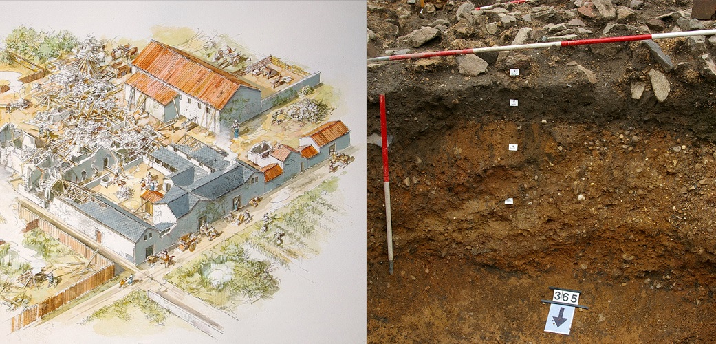
A concentration of good evidence for settlements and cemeteries have been found along a 15 km stretch of the river Wreake, close to most current villages. The Eye Kettleby excavations are the stand out settlement case study example[i].At the site were over 50 structures (both post-built and sunken-featured) over an area of c.3.5 ha. These were not all contemporary, more likely this was a small settlement of around 15–30 inhabitants, lasting several generations, shifting location a little over time, from the later 5th through to the 7th century. This is supported by a large quantity of ceramics and other objects, backed up with a strong radiocarbon dating programme. The site has been influential in improving the recognition of these hard-to-spot buildings, with structures now more readily recognised. Evidence also continues to accumulate for a settlement at nearby Melton Mowbray (buildings and burials are known). Finds from the surrounding area also point to people of high status in the locality, notably two rare gold bracteates and an early silver-gilt sword pommel cap have been found.
Chater and Gwash
In Rutland, several settlements are known, such as at Empingham, Oakham, and Barleythorpe. At Burley, a barrow cemetery yielded gold buckles and Coptic bowls of late 6th- to 7th-century date, indicating high-status burials or hoards. A high-status burial site has been long known at North Luffenham, whilst at Glaston, a more recent discovery of a cremation cemetery of 16 individuals, has added to the growing number of such discoveries .In eastern Rutland, there is evidence for continued use of the former Roman towns on Ermine Street, at Great Casterton, and Thistleton.
The Welland
Along the River Welland in south-east Leicestershire, extensive fieldwalking surveys have identified several settlements close to the north of the river, and close to former Roman roads. An excavation at West Langton located several inhumation graves. The Welland forms the county border, and so data is split between HERs. Interestingly, the Northamptonshire HER also contains a relatively high concentration of settlement and burial evidence on the south side of the river.
South and West Leicestershire
Evidence is also emerging west of the River Soar, an area previously viewed as largely outside early Anglo-Saxon settlement/influence. The evidence points to some concentrations of settlement close to Roman roads, such as Ravenstone, Measham, Snarestone, and Appleby Magna. At Kirkby Mallory, and at Brascote, structures and burials were found close to prehistoric ring ditches. The latter supported by radiocarbon dates of mid-5th to later 6th centuries.
Conclusion
With 100s of records of early/mid Anglo-Saxon date in the Leicestershire and Rutland HER, a large dataset now exists indicating patterns of active settlement zones. Settlement site excavations, such as those at Eye Kettleby, are crucial to flesh out the details, beyond simply another dot on the map, these allow us to get more detailed glimpses into everyday life some 16 centuries ago, seeing the buildings in which people lived, the objects they kept, their health and diet. The data should not be viewed in isolation, utilising the HER information from neighbouring counties offer much value in expanding horizons and understandings.
There is still much to be done with the middle Saxon period (roughly mid-7th to mid-9th century), only around 40 records are assigned to this period in the Leicestershire and Rutland HER, most relate to isolated findspots, mainly from metal detecting. In reality, some of the settlements listed above may be from this period. The mid-7th century onwards is viewed as one of transition from a dispersed settlement pattern towards the nucleated villages we see today. Finding these sites is restricted by the poor archaeological visibility of this period, much of the evidence likely lays largely inaccessible under existing village cores. Ceramics too are hard to precisely date, there are only limited numbers of diagnostic middle Anglo-Saxon imports from outside the region. Scientific dating has begun to help identify some new settlement sites, notably at Bottesford, Coston, and Claybrooke Magna. There are also new cemetery discoveries, such as at Rothley, Kibworth Harcourt, and Ketton. There are other resources available, such as place-name and documentary, that can aid research of this period.
No doubt future discoveries, and newer scientific tools, will help provide new insights on the people, their origins, and places, in this often poorly understood period of our past.
Learn More
To discover more detail on the Eye Kettleby Anglo-Saxon settlement, its features and finds, the book ‘The Anglo-Saxon Settlement at Eye Kettleby, Leicestershire’ is now available at Shop@le
References
[i]Speed, G. and Finn, N. 2024, The Anglo-Saxon Settlement at Eye Kettleby, Leicestershire. Leicester Archaeology Monograph 27.
[i]Smith, R.A. 1907. Anglo-Saxon remains, The Victoria History of the County of Leicester, Vol. 1, 221–242. London: Archibald Constable & Co Ltd.
[ii]Cotterill, F. 1946. Anglo-Saxon Leicestershire and Rutland. Illustrated Catalogue. City of Leicester Museum.
[iii]Dunning, G.C. 1952. Anglo-Saxon discoveries at Harston. TLAHS 28, 49–54.
[iv]Clough, T.H. McK., Dornier, A., and Rutland, R. 1975. Anglo-Saxon and Viking Leicestershire including Rutland. Leicester: Leicestershire Museums Art Galleries and Records Service.
[v]
Liddle, P. 1982. Leicestershire Archaeology, The Present state of Knowledge, Part 1 to the end of the Roman period. Leicester: Leicestershire Museums Art Galleries and Records Service Archaeological Report No. 4. Liddle, P. 1996. The archaeology of Anglo-Saxon Leicestershire, in Bourne, J. (ed.) 1996. Anglo-Saxon Landscapes in the East Midlands. Leicester: Leicestershire Museums, Arts and Records Service, 1–10. Knox, R. 2004. The Anglo-Saxons in Leicestershire and Rutland, in Bowman, P. and Liddle, P. (eds.) 2004. Leicestershire Landscapes. Leicester: Leicestershire County Council, Leicestershire Museums Archaeological Fieldwork Group Monograph 1, 95–104.
[i]Gretzinger, J., Sayer, D. and Justeau, P. 2022. The Anglo-Saxon migration and the formation of the early English gene pool. Nature 610, 7930. https://doi.org/10.1038/s41586...
[i]Buckley, R., Cooper, N., and Morris, M. 2021. Life in Roman and Medieval Leicester: Excavations in the town’s north-east quarter, 1958–2006. Leicester: Leicester Archaeology Monograph 26.
[ii]Speed, G. 2014. Towns in the Dark: Urban Transformations from Late Roman Britain to Anglo-Saxon England. Oxford: Archaeopress Archaeology.
Excavations at Eye Kettleby in the 1990s discovered many Anglo-Saxon buildings and artefacts, of a quantity rarely seen on a single site since. Credit: ULAS