
Sunday 20 October 2024
Ghost Woods of Leighfield Forest
Guest blogger, Andy Lear of the Wildlife Trust, sets out to re-discover the location of a lost area of woodland.
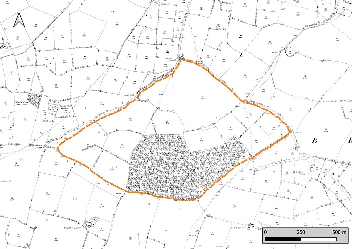
The Leighfield Forest in Rutland was a royal hunting ground along the western edge of the county of Rutland. It was a remnant of a very much larger area of Royal Forest comprising the Forest of Leicestershire and the Forest of Rutland created by Henry I in around 1100 and 1122, respectively. These Forests covered a large area stretching from Tilton on the Hill in east Leicestershire up to the Rutland boundary and onwards to include much of the south of Rutland. (Crooke, 2013; Squires, 2014) The Leicestershire Forest was released from Forest Law by Henry III in 1235 and most of the Rutland portion by Edward I in 1299. The remaining Forest was a strip of land along the Rutland border from Braunston in Rutland in the north to Stoke Dry in the south. (Fig. 1.)
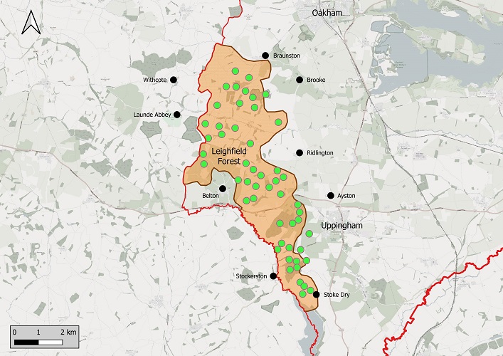
In 1500 this included all the current parishes of Beaumont Chase, Braunston in Rutland, Leighfield, Wardley and parts of Ridlington and Stoke Dry. By the end of the 16thcentury the Forest was in decline, and it was disafforested in 1622 by Charles I. The land was sold, and the woodland was rapidly cleared so that today only Prior’s Coppice, Stoke Dry Wood, Wardley Wood and two small fragments; Haycock Spinney (formerly Oldsale Wood) and Bushy Close (formerly Bushy Wood), remain of the 54 woods listed in the gazetteer of the woods of the Leighfield Forest (Squires, 2014).
Squires (2014) plotted the approximate location of many of the Leighfield Forest woodlands present in the mid sixteenth century and his putative locations are shown in Fig. 1. However, many of these woods have long since disappeared and their exact location is unknown. Where were they and can we still find traces of them in the landscape? Here I set out the search for the ghosts of the woods adjoining Prior’s Coppice in Leighfield and Brooke parishes.
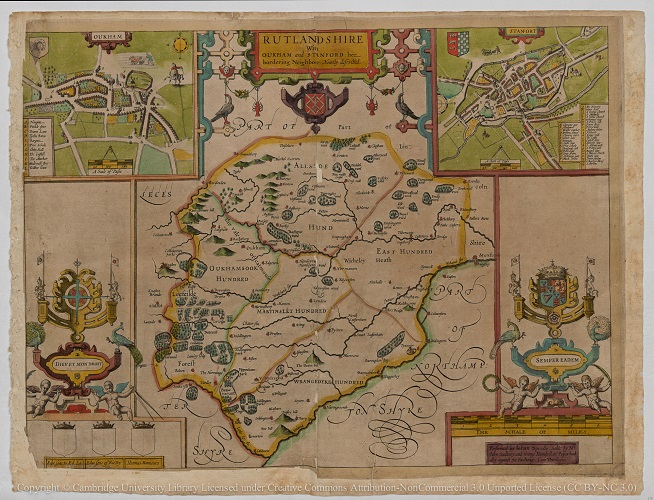
The earliest map showing the area in detail is that of Rutland by John Speed from 1611 (Fig. 2.). This shows the Leighfield Forest as well wooded with many individual woods delineated. Using digital mapping (GIS), we can align Speed’s map with present day maps. Fig. 3 shows the area of the Forest corresponding to the parish of Leighfield from Speed’s map, with the proposed locations of the mid sixteenth century woods taken from Squires (2014).
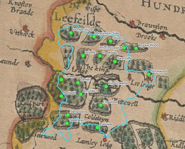
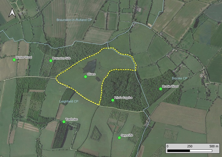
Fig. 4 is a current satellite image of Leighfield parish with the approximate locations of the Forest woods as suggested by Squires overlaid. Since the sixteenth century there have been many changes to the landscape. The grubbing up of woodland, clearing the trees and digging up their stumps, but also enclosure and the later removal of hedgerows to facilitate modern agriculture. In the second half of the twentieth century much of the parish was converted to arable from pasture but much has now reverted to a mix of grassland and new woodland plantations (Fig. 4.). However, some old boundaries survive.
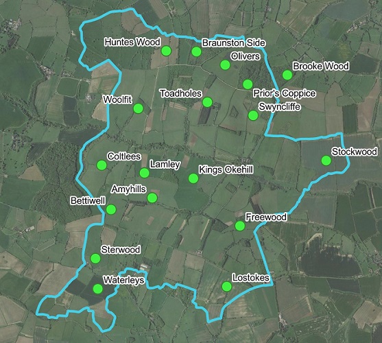
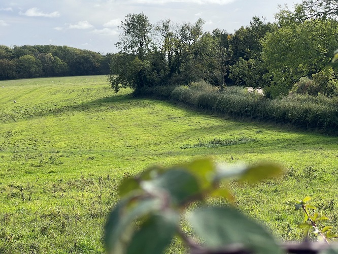
Fig. 5 shows a more detailed look at the area around Prior’s Coppice. What is striking from this image is the sinuous hedgerow encompassing the area labelled Olivers combined with the Forest portion of Prior’s Coppice. This contrasts with the linear hedgerows of the post enclosure landscape to the south of the wood. This could well be the outline of an old wood.
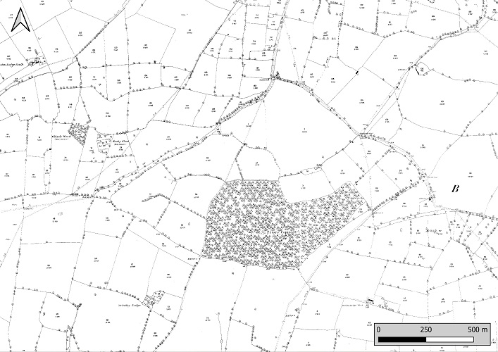
It can also be seen on the first edition 25” Ordnance Survey (Epoch 1, 1846-1899) map (Fig. 6.). These maps are particularly useful for helping to recognise old features since they show the field patterns before they became modified in the second half of the 20th century.
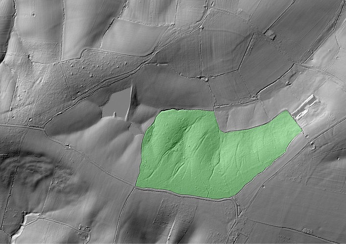
Many woods enclosed before 1600 would have had rounded outlines, although subsequent changes to land use can mean that they have since been straightened. Woods with boundaries defined in Anglo-Saxon or medieval times were often surrounded by large banks and ditches. These would have been topped with a pale fence or hedge with the purpose of excluding grazing animals or retaining deer for hunting. Where these survive, they are typically much broader than similar banks arising from later enclosure and can often be seen on LiDAR images as shown in Fig. 7. This shows banks and ditches marking the postulated woodland to the west of Prior’s Coppice. However, note that what appears to be a prominent bank running along the southern boundary is in fact a modern raised track. It is therefore important to check the situation on the ground before making any conclusion as to how old a feature may be. The bank and ditch along the northern and eastern edges are likely to be older especially as the latter forms part of the parish boundary with Brooke.
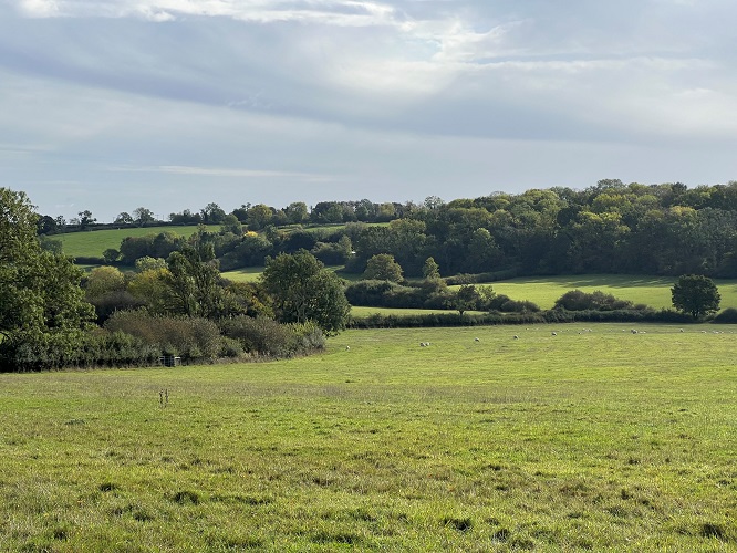
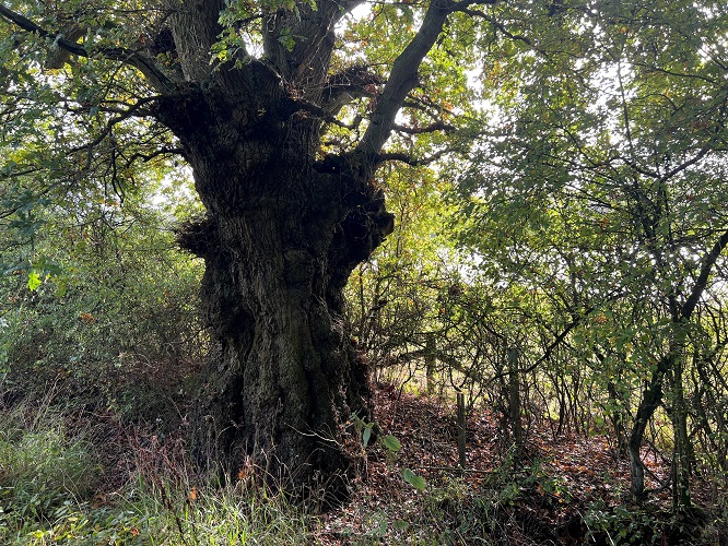
The northwest part of the boundary runs parallel to an old drove road called Wood Lane (Fig. 8.). The bank is marked with a number of mature pollard oak trees – another indication this could be old boundary. However, it doesn’t have many ancient woodland indicator plant species growing on it. (Ancient woodland indicator species are plants which have a high association with ancient woodland. Strong indicators include species such as wood anemone, Anemone nemorosa, woodruff, Galium odoratum, wood melick, Melica uniflora and bluebells, Hyacinthoides non scripta in areas away from old heathland). So, is this the ghostly outline of a former woodland? Without stronger evidence on the ground, confirmation requires additional documentary support. Ideally this would be old maps, but field names can be helpful too. For Rutland, the best source is The Place-names of Rutland (Cox, 1994).
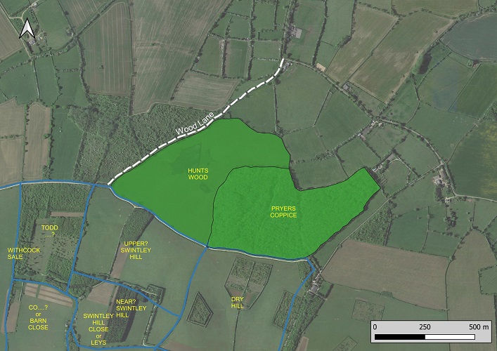
A search of the catalogue of the Record Office for Leicester, Leicestershire and Rutland (ROLLR) turned up a ‘Plan of Ridlington and Leighfield’ dated between 1625 and 1640 (DE3214/4605). Closes and woods shown on this map are drawn in Fig. 8. Hunts Wood is named and occupied the area west of Prior’s Coppice. It is clear that this is the ‘ghost wood’ outlined by the ancient field boundaries visible on aerial photographs and current maps. It was woodland beyond the disafforestation of Leighfield but had been cleared by 1806 as shown on a map of that date (A tract of country around Belvoir Castle, William King, ROLLR: Ma/L/23). There is some evidence that it might have survived until the second half of the 18th century. A 1780 Estate map of Leighfield by William Cullingworth (ROLLR: DE3443) shows the wood divided into three named closes: Hunts Wood Meadow, Upper Hunts Wood and Little Hunts Wood indicating some but perhaps not all of the wood had been grubbed out by that time. In addition, Captain John Andrews 1781 Map of Rutland (ROLLR: DE3214/4745) shows all the area either side of Wood Lane as woodland. But this should be interpreted with caution since this is not the most reliable map when it comes to depicting woods.
Another conclusion from this research is that the location of Hunts Wood and Olivers postulated by Squires (2014) needs to be adjusted as the former can now be placed with certainty adjacent to Priors Coppice. The maps in the Record Office also allow a number of the other Leighfield Forest woods to be located with much greater accuracy, but this will not be covered here.
For the present purpose of illustrating how you might locate former woods I will consider one more site. If you inspect the 1880 25” ordnance survey map (Fig. 11.) you can see a large diamond shaped area which includes Priors Coppice and Hunts Wood plus a series of enclosures to the north and east. There is some evidence that this too might have once been woodland.
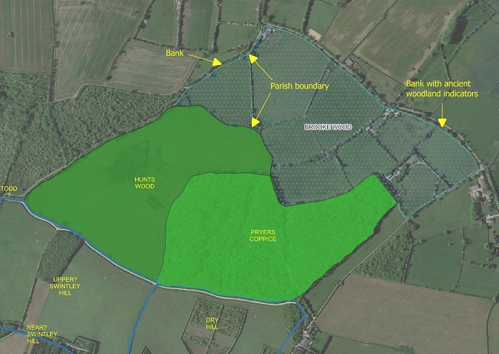
Brooke Wood was the name of the east part of the current Prior’s Coppice lying in Brooke parish. It belonged to Brooke Priory, a small religious establishment on the edge of Brooke village which was endowed with about 90 ha of woodland some time before 1153. Apart from the section of Prior’s Coppice (8.5 ha), Brooke parish now has no ancient woodland, and this reflects the situation in 1611. So where was the rest of the woodland? I suggest that at least part was in the area to the north and east of Prior’s Coppice. (Fig. 12). Studying maps and visiting the site itself reveals relevant features such as curving hedgerows, evidence of old banks, the line of the parish boundaries, and the presence of ancient woodland indicators such as bluebells, wood anemones and early purple orchids in the hedge bottoms. The latter are best seen at Shipley’s Common, an area of grassland beside the road to Braunston. A 1679 Plan of the Manor of Brooke by Vincent Grant (ROLLR: DE3214/4552) shows this area as three closes with different tenants, whilst Prior’s Coppice is shown as woodland with its current boundary. Therefore, if this was once woodland, it was cleared before 1679. A likely timing is between the dissolution of Brooke Priory (1535), the subsequent acquisition of the land by the Noels (1541) and 1611, as it is not shown on Speed’s map. Overall, my conclusion is that this area was woodland, but without a supporting map or documentary evidence, the case for it is not as strong as for Hunt’s Wood.
The aim of this article has been to describe how lost medieval woodlands can persist in the landscape as ghost outlines within the modern field system, giving examples of how they might be recognised. As with all such efforts, it contains an element of subjectivity and outright guesswork, but perhaps it will inspire you to look for evidence of similar shadows within your local area.
Andy Lear. Ancient Woodland Inventory Officer at The Wildlife Trust for Bedfordshire, Cambridgeshire & Northamptonshire. 2024
Citations
Cox, B.,1994. The Place-names of Rutland, English Place-name Society
Crook, D., 2013. The Royal Forest of Leicestershire, c1122-1235 Transactions of the Leicestershire Archaeological and Historical Society, 87, 137-160
Squires, A., 2014. Leighfield Forest: Woodlands and Landscape in the Sixteenth and early Seventeenth Centuries, Rutland Record, 34, 155-179
A veteran oak boundary pollard on the bank forming the former north edge of Hunts Wood, looking from Wood Lane towards Priors Coppice. Photo by A Lear (2024)