
Sunday 6 April 2025
Ancient Trails & Salt Ways in South Leicestershire
LAHS Member, John Lacey, investigates a lesser known pre-historic trading route from north to south.
A number of prehistoric routes are known to have traversed the northern parts of Leicestershire, which are usually considered to be salt ways for the transport of salt from the coast of Lincolnshire, which may have been considerably further west than the present coastline. Evidence of similar routes in the southern half of the county is sparse.
By chance, a terrier attached to a 17th century document was discovered which contained references to land “abutting upon Saltstreete Waye. This terrier referred to lands in Husbands Bosworth in the very south of the county, an area hitherto not associated with salt ways. There was little to indicate where in the parish such a route might be and unfortunately little is known about pre or post enclosure field names in that parish, the Women’s Institute Survey, a national scheme carried out to record parish field names in the 1960s and 70s initiated by Professor. W. G. Hoskins, being incomplete and without a map. Undaunted, I proceeded to try to trace where such a route might be going to and coming from.
Traditionally the village of Mowsley is said to be on a Bronze Age track, previously this had led me to search for any evidence of such a track and if it existed. A description of this route was made in 1911. Professor W.G. Hoskins conjected this to be a branch of the legendary Jurassic Way, which entered Leicestershire at Husbands Bosworth between the heads of the rivers, Welland and Avon, running northwards across the county towards its destination in Yorkshire [1]. More recently, Michael Wood described this route to be heading towards The Wash, which was anciently a source of salt from salt pans [2]. Barrie Cox provides further clues to the course and nature of this route in the form of field names [3]. Further research has established this prehistoric route running through Mowsley village to be one of a network of ancient trails. It is attempted here to follow the route, parish by parish with field names, to provide additional evidence for its existence.
Michael Wood describes a track, long stretches of which are followed by parish boundaries. Part of this at least was known as le. Ferdgate (Old Englsh (OE) ferd ' an army' Old Norse (ON) gata 'road'), such routes were nominated as Herepath (army path) by the Anglo Saxons. This was originally a prehistoric trading route, part of which lent itself to the transportation of salt. When salt began to be carried inland is questionable, but a recent excavation in Loftus in Yorkshire has revealed what is described as an early Neolithic salt factory, presumably producing salt for trading [4].
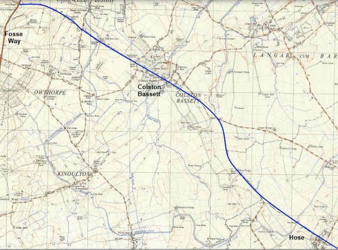
If Hoskins' conjecture was correct, the route most probably crossed the River Trent by means of one of the fords between Gunthorpe and East Bridgeford, before running south-eastwards along Bridgeford Street to Margidunum on the Fosse Way, on to Colston Bassett and thence along Street Waye into Leicestershire towards Harby.
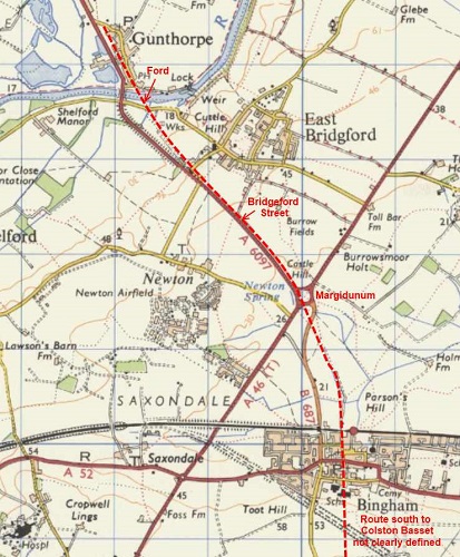
The name element ’stret’ and variations such as straet, strete or street, as here in Street Way, are usually associated with a Roman road, place names such as Stretton being a typical example. However, the OE word 'Stræt' referred to a paved way and may well allude to ancient ways or trails other than Roman ones, Street Waye was formerly paved and may have been such a route, although both Wood and Cox suspect that at least part of the route discussed here may have been used by the Romans [5].
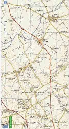
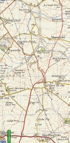
The county boundary follows a length of the road with Harby parish to the east in which a furlong named le Ferdgate existed in the 13th century. It continued south through Hose village before climbing Brocks Hill near Long Clawson and then continued south following a ridge forming the watershed between tributaries of the Welland and Soar, before crossing a Roman Road to the north of Scalford [6].
It is followed by the western boundary of Scalford and then skirts a field named Great Framlands, believed to be the site of the moot for Framland Wapentake before entering Melton Mowbray where it is thought to have crossed the River Eye (known as the Wreake downstream of Melton Mowbray) at the 'old ford' [7].
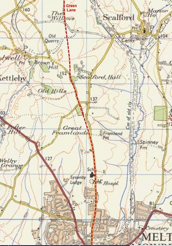
South of the river at Melton Mowbray it crosses a salt way (Sawgate Road) west of Burton Lazars, this being one of several such routes traversing east to west in the area [8]. Salter's Field in Scalford is the first hint of a salt way, but south of Burton Lazars the route considered here would appear to have been used as a salt way (see below) and may also have been used by the Romans.
It continues south following the watershed between the rivers Soar and Welland, along Sandy Lane, passing between the two Dalby villages before skirting the western side of Burrough Hill hillfort where it passes over Salters Hill then west of Burrough on the Hill village and south through Marefield parish to Tilton where it appears to run just to the west of the existing village.
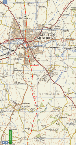
South of Tilton, the route is followed by the eastern parish boundaries of Billesdon, Frisby and Illston on the Hill before reaching Three Gates, where it appears to fork, with one branch heading south across the Gartree Road at a point that Cox claims is at or close to the legendry Gartree Bush, the moot site of the Gartree Hundred, from where it heads south to Tur Langton and the Market Harborough area and probably beyond.
The main branch heads south westwards, passing to the east of Carlton Curlieu and on to Kibworth Harcourt.
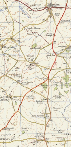
The route through the two Kibworth villages and on to Saddington is not readily apparent but is generally assumed to pass through Smeeton Westerby, however that would seem to involve deviating from the direct line and also leaving the high ground with a steep climb out of the valley to Saddington. A more logical route would be to the north of Smeeton Westerby on or near the road known as Warwick Road running towards the north of Saddington thus keeping to higher ground. Warwick Road is so named due to it being used by the Earls of Warwick when travelling to attend courts at Kibworth Beauchamp, which would suggest that an established route existed in the 12th century, on or close to the line of the present road. A Streete Furlong existed in 1636 and Streatfold in 1850 but the location of these is not known.
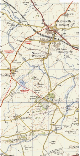
Immediately north of Saddington the route meets with another trail running south from what is now Leicester. In medieval times this was the main route from Leicester via Welford to Northampton and thence to London. Welford Road out of Leicester (the old London Road)’is broadly in line with the road from Wigston to Newton Harcourt, Fleckney, Saddington and Mowsley. This road in turn is in line with the Husbands Bosworth to Welford Road and was in fact a more direct route from Leicester to Welford than any other until the building of the turnpike, now followed by the A5199.

Turning south, the route runs just to the west of Saddington village and along a short length of the Mowsley Road before descending to and crossing a brook at or near the footbridge serving the present footpath before climbing on the line of the footpath (part of which was diverted in modern times) up to the ridge and the Mowsley Road. Parts of this route show on Lidar maps.
Branching from this route by the western end of Saddington was the road to the ancient meeting place at Gumley. This is probably followed by the present road to Mowsley to or near to the point where Reservoir Road branches off towards Gumley. The original route of this road was under what is now Saddington Reservoir. The main route ran south along the ridge into and through Mowsley. Almost certainly, Mowsley developed along the ancient track which originally ran on a more direct line, the present road layout being planned probably in the 13th century. South of the village, the line is followed by the footpath heading south-west. This path was flanked on the north side by Ridgeway Furlong and was respected by the ridge and furrow. On what is now the boundary between Gartree and Guthlaxton hundreds, the trail forked with one branch heading south and the other westwards (see below).
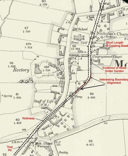
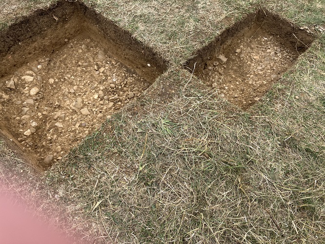
Recently a trial pit was dug on the line of the route immediately to the south of Mowsley village. This revealed a cobbled surface that would indicate that the route was still regularly used in medieval times. Further research is needed to try to establish the age of the route.
The south branch is followed by the hundred boundary and now forms part of the A5199, sticking to the watershed it runs over the head of a spur of the Welland valley before slowly descending into Husbands Bosworth and on to join what is popularly known as the Jurassic Way at Welford. What is thought to be a later alternative route (probably early medieval) branches south at the southern end of Mowsley village. This route is followed by the Theddingworth Road, footpaths and the bridle road which runs into Mowsley Road in Husbands Bosworth. Smalstret in a Leicester Abbey terrier (1467) is believed to refer to this alternative route whilst Streetway may allude to the 'main' route.
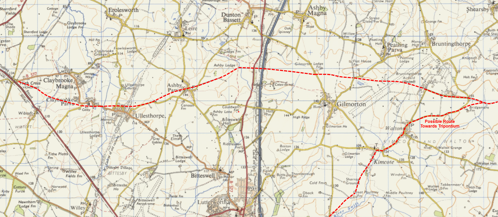
The western route continues along a ridge that is now the watershed between the Rivers Soar and Avon. It is followed by a track and then road which is followed in turn by a long length of the boundary between Bruntingthorpe and Kimcote parishes. In the latter, there are numerous clues to the existence of one or more ancient trackways. The road continues in a straight line towards Peatling Parva followed by the north-east boundary of Gilmorton parish. This route appeared to be known locally as The Ridgeway. This name crops up in the form of field names, first in Mowsley, followed by Kimcote and Walton, Gilmorton, Peatling Parva and finally in Claybrook Parva. There is a certain amount of conjecture re the precise route between Ashby Parva and Claybrooke Parva, but there is little doubt that the route passed through these parishes and Ullesthorpe.
John Lacey (2025)
Tracing the Route(s) with Fieldnames
Old fieldnames or furlong names can be useful clues to former features in the landscape and the only clues to the existence of ancient salt ways coming into south Leicestershire are in the form of such names. Which way salt would have travelled in south Leicestershire is difficult to determine. For instance Droitwich is closer to Husbands Bosworth than the coast of Lincolnshire, whilst Cheshire is almost as close to Claybrook as the Lincolnshire coast. It can be seen below that with the exception of Tur Langton no reference to Salt way or similar appears south of Billesdon until Kimcote and Walton is reached. Could this be where salt travelling from the east met with that coming from the west? Field name reference to salt ways in the southern fringe of the county would suggest that salt was coming into Leicestershire from the south and west.
Harby
le Ferdgate (13th C) Ran south via Brock Hill to Scalford. Later known as Melton Gate.
Extract from an ancient deed [Harby]:
Grant by Walter son of Roger de Herdebi, to Agnes, daughter of Roger the clerk, son of Gilbert de Herdebi, of land and meadow in Herdebi, part at the end of
'le dede hevidland' part below Blacmild, part below Litilhevig, part in Crocland, part upon Wrongland, part upon 'le Redehil', part upon Densewellefurlang, part abutting 'in le Ferdgate' and part in Wadland. n.d.
Scalford
Salter's Field The Saltway which was on the western boundary of the parish is the same route as le Ferdgate.
The Streete Furlonge (1601) Probably the Roman road through the north of the parish identified by Margary (linking Ermine Street with Fosse way).
Ye Strete Furlong (1674) Street Furlong (1730)
Melton Mowbray
Saltegate (1445) Saltergate (1449)
Burton Lazars
Sawgate Road An east-west route probably the same as Saltgate (13th C and 1404)
Saltgatte Bryge (1288) Probably the bridge carrying the above over Burton Brook.
Saltegatelonge (1449) Brode Saltgate (1550) Saltgate feilde (1561) These may allude to the above road or to the southbound route considered here.
Burrough on the Hill
Salters Gate (1607) Ran to the west of the hill fort over Salters Hill.
Billesdon
Saltgate (1601)
Skeffington
The Strete possibly the same as Stainsgate (stony road).
Shangton
le Ferdgate (13th C)
Stanegate (1295) Probably Gartree road.
Tur Langton
Fargate (1601) Probably a corruption of 'Ferdgate'. Rushe Fargatts (1601)
Salters Peece (1601) Almost certainly alluding to land alongside the above route.
Kibworth Beauchamp
Stonypath Furlong (1694 to 1724) Stoney Path (1771)
Smeeton Westerby
Streete Furlong (1636) (later The Street)
Streatfold (1850) almost certainly the same as or named after Long Steadfold (1650) which itself may have followed Streete Furlong (1636).
Mowsley
Smalstret (1464) in Swarborough Field. Possibly refers to the Husbands Bosworth path.
Streetway in Beesick Field (found in a document dated 1714 in the Exton collection)
Ridgeway Furlong (1659) Rigeweye (1467) (located alongside the Walton path).
Bruntingthorpe
Strete Field (1625) The Midle Feild called Strete and More Feild. Variations of this to the mid-18th C. This was one of the common open fields.
Kimcote & Walton
The name Walton alludes to a prehistoric settlement probably developed on the line of the route considered here.
Saltergate (1318) Saltersgateweye (14th C) Saltersgate Weye (1576)
Saltergate Way (1745)
Riggeweye (1318) Rydichewey (1467) Ridgeway (1720) This is almost certainly the same route as Ridgeway in Mowsley and is probably followed by the northern boundary of the parish.
Stonyforde (1579) Stonieford (1745) Probably alludes to a ford over the River Swift.
Gilmorton
Ridgeway (1606) Referring to the route similarly named in Mowsley and Walton. Probably followed by the parish boundary with Peatling Parva and Ashby Magna.
Dunton Bassett
Oult Highway (1762) The Olt Highway (1697) The Oldway (1591)
Old Waie Side/Syde (1601) Old Way Side (1674) These may allude to a road or way no longer used. Field names survive which need locating.
Peatling Parva
The Ridge Way (1625) See Ridgeway above.
Chesters Way (1625) May refer to Cheshire - source of salt.
Throwlesworth Furlonge (1601), Frolseworth Forlonge (1625) There is no evidence of this being a family name. It may refer to the ancient route leading to Frolesworth 5 miles west. See Claybrook Parva.
Ashby Parva
Street Close (1847) Street Seed Close
"Qeenes High Way called Common Street" (1589)
These could allude to the Leicester Road thought to be Roman.
Ullesthorpe
A direct route principally as a pathway runs from Ullesthorpe through Claybrook Parva parish to the High Cross site of Venonis. (Barrie Cox p205 Part 5 The Placenames of Leicestershire). See Claybrook Parva.
No records earlier than 19th C are referred to.
Claybrook Parva
The Streete Way (1638) Beside Watling Street. Streete Leas (1625)
Paealdan stroet (962?) Watling Street
Path Lands (1625) Great Path Lands (1638)
Discussion re Saxon Charter (962) re woodland estate at Claybrook: Apelnodes gemære 'Athelnoth's Boundary'. This boundary may be represented nowadays by the path which runs from High Cross to the old school site in Claybrook Parva and so straight on via a sunken overgrown lane to Ullesthorpe. This track has every appearance of being an ancient one whose destination was once Venonis. (Barrie Cox p.64 Part 5 The Place- names of Leicestershire).
Ridgeway (1577) Riþiges (962) These may allude to the above path or track. Peatling (1638) and Peatling Thorne (1674) possibly refer to the Peatling villages 6 - 7 miles to the east.
Branch South to Jurassic Way
Husbands Bosworth
The relevant pieces of a mid-17th century document read:
In Mill Field. "...on a little furlong beyond William Burdetts Close and abutting upon Saltstreete Waye"
In Southwest Field. "...one rood on a furlong called Langrobes Furlong shooting into Saltstreete Waye from the joynt being one distant from the baulk called Bartles Baulk
This would indicate that the route traversed two of the open fields of Husbands Bosworth and probably headed towards Welford (Northants.) at the southern extremity of the parish.
In Husbands Bosworth, a cache of Bronze Age tools etc. was found in 1801 in Gravel Pit Close, recently there have been further Bronze Age finds including axe heads. A Causewayed Enclosure dating from approximately 3500 BC was discovered south of Husbands Bosworth on or by the line of the route. There is good reason to believe that the Husbands Bosworth settlement developed on or alongside this route, it is generally believed that the village developed along the line of Mowsley Lane, which is a continuation of the route followed by a bridle road and footpaths from Mowsley. The present layout of the village has been strongly influenced by the former turnpikes.
Branch towards Tripontium
Kimcote & Walton or Gilmorton - see above.
Misterton Including Walcote and Poultney
Salters Way Furlong (1680)
Shawell
Streete Furlonge (1606) In the 1606 terrier, Watling Street is referred to as such which suggests that these names refer to another route.
The Streetway (1606)
Sources
[1] Memorials of Old Leicestershire 1911 THE PREHISTORIC ROADS OF LEICESTERSHIRE p.36 (Harold Peake)
[2] The Story of England, Michael Wood 2010, pp.1-2.
[3] The Place Names of Leicestershire, Barrie Cox 2009, Part Four: Gartree Hundred.
[4] Early Neolithic salt production at Street House, Loftus, north-east England. Stephen J. Sherlock Antiquity 2021 Vol. 95 (381): 648–669.
[5] The Place Name Elements II EPNS, A.H. Smith 1956, vol. 26.
[6] Ivan D. Margery 58A Six Hills to Grantham
[7] Leicestershire Moot Sites, B. H. Cox 1971-72, LAHS Transactions, pp.14-21.
[8] This appears to be a corruption of Saltgate
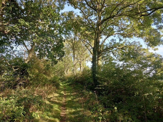
Trial Pit dug to the south of Mowsley Village on the location of the trackway. © Oadby and Wigston Fieldwork Group (c.2024)